

RhinoSolar
Reveal the solar potential of your infrastructures!
Turning the solar energy received by a surface into electricity is a major challenge for cities looking for a quick and efficient transition to sustainable energy systems.
From a complete 3D digital model including terrain, vegetation, buildings any other potentially "masking" elements, RhinoSolar™ allows to evaluate the solar potiential of your infrastructures.
SOLAR ENERGY
RhinoSolar™ computes very precisely, taking in account the 3D visibility complex, the 3 components of the solar irradiance:
The global solar irradiance (power in W.m-2) is the sum of these 3 components. It makes it possible to determine the solar irradiation on a given period of time (energy in Wh.m-2).
 Based on this "clear-sky" solar energy, RhinoSolar™ can also manage the impact of cloud cover to determine sunshine.
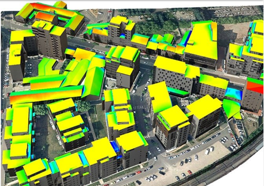
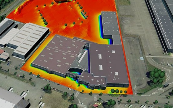
URBAN HEAT ISLAND (UHI)
An Urban Heat Island (UHI) is an urban area that is significantly warner than its surrounding rural areas due to human activities.
Compute the sunshine duration is the key point of UHI analysis. Using RhinoSolar™ you'll be able to:
RhinoSolar™ produces usable numerical results in Excel or SQLite, as well as textured 3D models from totally customizable gradients: let your creativity expose the solar potential of your data!
ALL POSSIBILITIES OF COMPUTATION

GLOBAL SOLAR IRRADIATION
Computation of the 3 components of global "clear sky" solar irradiation: Direct, Diffuse and Reflected

CLOUD COVER
Management of the impact of cloud cover by reduction coefficients or by octas values

SUNSHINE DURATION
Computation of sunshine duration: useful for analysis of Urban Heat Islands (UHI)
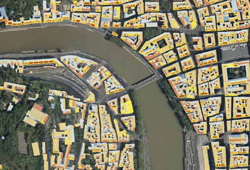
THE SOLAR CADASTRE OF LYON IS ONLINE!
The solar cadastre allows to know the level of sunshine of each roof, i.e. the solar energy received by each square meter of a roof over a given period (in kWh / m² for one year).
The roofs are colored according to their sunshine, with a 6-level gradient ranging from "excellent" to "bad". The solar cadastre also indicates the total amount of energy that can be produced over a year by installing photovoltaic solar panels (kWh / year).
Produced using RhinoCity™ the Lyon Metropolis has a very accurate 3D model of its territory: each building, each roof, is modeled.
Thanks to RhinoSolar™, based on this model and the sun's course for a year, the sun was calculated for each roof section. The visibility of each 3D element present in the model has been taken into account during the calculations. Thus, if a tree, building or urban equipment obscures the sun, it is integrated in the calculation. Only taking into account the global visibility complex allows the development of a reliable and realistic solar cadastre.
TAKING INTO ACCOUNT THE COMPLETE 3D MODEL
RhinoSolar™ calculates the solar potential and the sunshine duration of all surfaces by taking into account the complete 3D digital model to which they belong.
By taking into terrain, vegetation, buildings and all other potentially masking elements, RhinoSolar™ is an unprecedented solution for exploiting a territory's 3D digital model.
MULTIPLES WAY OF PRESENTING THE RESULTS

All the characteristics of the studied surfaces (identifier, surface, slope ...) as well as the results of computation are available as a CSV file directly exploitable in Excel.

SQLite database export: the high-reliability, embedded, full-featured and public-domain SQL database engine

Your 3D model is textured for easy reading of the results by gradients with customizable colors. You can also create geo-referenced vertical images of type GeoTiff.

Exported as attribute data from the 3D geometries studied, the calculation results are directly integrated into the 3D model when exported in CityGML format or in Shapefile (ESRI) format.